Paving the Future: AI-Powered Pothole Segmentation for Smarter Road Maintenance
Introduction
Road infrastructure is the backbone of modern society, facilitating commerce, commuting, and everyday life. However, the relentless forces of traffic, weather, and time lead to inevitable wear and tear, with potholes emerging as one of the most common and problematic forms of road degradation. These seemingly minor defects pose significant threats to road safety, causing vehicle damage, accidents, and substantial economic burdens for municipalities and vehicle owners alike. Traditional methods of pothole detection, often relying on manual inspections, are time-consuming, costly, inconsistent, and reactive rather than proactive.
Artificial Intelligence, particularly through advanced computer vision and precise image segmentation techniques, is paving the way for a revolutionary approach to road maintenance. By enabling autonomous, precise, and scalable identification of road defects, AI-powered pothole segmentation promises to transform how we manage and preserve our vital transportation networks. This blog post explores our cutting-edge AI model designed for accurate pothole segmentation, highlighting its technical capabilities, profound clinical benefits, diverse applications, and the significant impact it promises for enhancing road safety and infrastructure longevity.
1. The Critical Need for Automated Pothole Detection
The urgency for efficient and accurate pothole detection and segmentation stems from several critical factors, directly impacting public safety, economic stability, and infrastructure sustainability:
Enhancing Road Safety: Potholes are a significant cause of accidents, especially for motorcyclists and cyclists, and can lead to sudden loss of control for all vehicles. They also contribute to tire blowouts, damaged suspensions, and steering issues, compromising vehicle integrity and occupant safety. Proactive identification prevents these hazards.
Minimizing Vehicle Damage and Repair Costs: For vehicle owners, striking a pothole can result in costly repairs to tires, wheels, suspension systems, and steering components. For fleet operators, this translates to significant downtime and maintenance expenses. Automated detection minimizes these financial burdens.
Optimizing Infrastructure Longevity: Unrepaired potholes grow larger and deeper over time, exacerbating road damage and accelerating the degradation of the surrounding pavement. Early detection and targeted repairs can prevent minor defects from escalating into major, more expensive structural failures, extending the lifespan of roads.
Improving Maintenance Efficiency and Resource Allocation: Manual road inspections are slow, labor-intensive, and prone to human error or subjective assessment. Automated segmentation provides objective, precise data on pothole locations, sizes, and potentially severities, enabling maintenance crews to prioritize repairs strategically and allocate resources more efficiently.
Economic Considerations for Municipalities: Governments and local authorities spend billions annually on road maintenance. By streamlining detection and enabling predictive maintenance, AI can significantly reduce operational costs, freeing up public funds for other essential services.
By addressing these multifaceted challenges, AI-powered pothole segmentation is not merely a technological convenience; it’s a fundamental step towards safer, more durable, and cost-effective road infrastructure for the benefit of all road users.
2. Benefits of AI in Pothole Segmentation
AI-powered pothole segmentation systems offer a multitude of transformative benefits that are reshaping road maintenance practices:
Proactive and Predictive Maintenance: Unlike reactive approaches, AI enables continuous, systematic monitoring of road conditions. This allows maintenance teams to identify emerging potholes and schedule repairs before they become severe hazards or cause extensive damage, shifting from reactive fixes to proactive upkeep.
Enhanced Accuracy and Consistency: AI algorithms process images objectively, providing highly consistent and precise segmentation masks of potholes regardless of human fatigue or subjective judgment. This ensures uniform data collection and defect assessment across entire road networks.
Unparalleled Scalability and Speed: AI systems can analyze vast quantities of road imagery captured from vehicles or drones at high speeds. This capability is crucial for rapidly surveying large road networks, identifying thousands of defects in a fraction of the time it would take manual inspectors.
Data-Driven Resource Allocation: By providing detailed geolocated data on pothole size, type, and severity, AI generates actionable insights. Maintenance departments can use this data to prioritize repairs based on criticality, optimize crew deployment, and manage budgets more effectively, maximizing the impact of every repair effort.
Improved Safety for Inspection Teams: Automating the inspection process with AI-equipped vehicles or drones reduces the need for human inspectors to be on potentially dangerous roads, enhancing the safety of personnel involved in infrastructure maintenance.
3. Data Preparation for Robust AI
The success of our pothole segmentation model is directly attributable to the meticulous preparation of a diverse and high-quality dataset. This process involved collecting and annotating vast numbers of road images, encompassing a wide range of real-world scenarios and defect characteristics. Key aspects of our data preparation strategy included:
Diverse Road Surface Types: The dataset included images from various road materials (e.g., asphalt, concrete) and conditions (newly paved, aged, cracked) to ensure the model’s robustness across different road textures.
Varying Pothole Characteristics: Images featured potholes of different sizes, shapes, depths, and severities, from small surface cracks to large, deep cavities, enabling the model to accurately segment a full spectrum of defects.
Challenging Environmental Conditions: The dataset incorporated images captured under diverse lighting (bright sun, overcast, twilight, heavy shadows), weather conditions (dry, wet, snowy), and road environments (urban, rural, highways) to enhance the model’s generalization capabilities.
Pixel-Level Annotation: Each pothole within the images was precisely outlined at the pixel level, creating accurate segmentation masks. This detailed and precise labeling by domain experts served as the indispensable ground truth for supervised learning.
Comprehensive Data Augmentation: To artificially expand the dataset’s diversity and improve model robustness against variations, techniques such as rotation, scaling, cropping, brightness adjustments, and simulated environmental changes were applied.
Model Architecture
The foundation of our advanced pothole segmentation system is the YOLOv9m architecture. While YOLO (You Only Look Once) is primarily recognized for its efficiency in object detection, its capabilities have evolved to include instance segmentation, allowing for pixel-level delineation of objects. This specific variant was chosen for its optimal balance of high accuracy and impressive inference speed, making it perfectly suited for real-time road infrastructure monitoring.
Key advantages of YOLOv9m in the context of pothole segmentation include:
Real-Time Processing: YOLOv9m’s highly optimized design allows for extremely fast analysis of road images, enabling near-instantaneous detection and segmentation of potholes from moving vehicles or drones.
Multi-Scale Segmentation: Potholes can vary dramatically in size, from small, nascent cracks to large, expansive damages. YOLOv9m excels at accurately segmenting these defects across a wide range of scales within an image.
Robust Feature Extraction for Irregular Shapes: The model’s sophisticated deep learning layers are highly effective at extracting intricate features from the irregular and often complex shapes of potholes, enabling precise boundary detection even in challenging visual scenarios like shadowed areas or textured surfaces.
Efficient Mask Generation: Beyond just bounding boxes, YOLOv9m generates detailed pixel-level masks for each identified pothole, providing the precise segmentation output necessary for accurate size and shape measurement.
Training Parameters
The model underwent extensive training to optimize its performance across the diverse dataset. The key training parameters were carefully selected to ensure stability, rapid convergence, and robust generalization to new, unseen road conditions:
Parameter |
Value |
Description |
|---|---|---|
Base Model |
YOLOv9m |
The foundational deep learning architecture employed for the task, known for its efficiency and accuracy in instance segmentation. |
Batch Size |
8 |
Number of samples processed before the model’s internal parameters are updated, balancing training stability and computational efficiency. |
Learning Rate |
0.0005 |
Controls the step size during the optimization process, a conservative rate chosen for stable convergence and fine-tuning. |
Epochs |
70 |
Number of complete passes through the entire training dataset, ensuring the model learns extensively from the data and generalizes well. |
Optimizer |
AdamW |
An adaptive learning rate optimization algorithm (Adam with decoupled weight decay) known for its efficiency and strong performance in deep learning tasks. |
Inference Time |
~0.5s |
The average time taken for the trained model to process a single road image and generate pothole segmentation masks. |
Model Evaluation
Our rigorous training and validation processes have yielded a model with robust capabilities for pothole segmentation. The evaluation metrics below demonstrate the model’s high precision, strong recall, and overall segmentation accuracy, proving its reliability for real-world road infrastructure monitoring applications.
Metric |
Overall Performance |
Well-Segmented Potholes |
Challenging Potholes |
|---|---|---|---|
Precision |
0.81 |
0.85 |
0.78 |
Recall |
0.81 |
0.85 |
0.75 |
F1 Score |
0.81 |
0.85 |
0.76 |
mAP |
0.74 |
0.80 |
0.70 |
Inference Time |
~0.5s |
- |
- |
Precision (0.81 Overall): This indicates that when our model identifies pixels as belonging to a pothole, it is correct 81% of the time, minimizing false positives and ensuring efficient resource allocation for actual defects.
Recall (0.81 Overall): With a recall of 81%, the model successfully identifies most of the actual potholes present in an image. This is crucial for ensuring that significant defects are not missed, enhancing road safety.
F1 Score (0.81 Overall): The F1 Score, a harmonic mean of precision and recall, provides a balanced measure of the model’s overall accuracy in segmentation, reflecting its robust performance in both identifying and correctly outlining potholes.
Mean Average Precision (mAP) (0.74 Overall): As a comprehensive metric for object detection and segmentation tasks, mAP of 0.74 signifies solid overall performance across various pothole types and scales, indicating reliable accuracy in generating precise masks for road defects.
Inference Time (~0.5s): The sub-second inference time ensures that pothole segmentation can be generated in near real-time, making the system highly practical for integration with vehicle-mounted inspection systems or drone surveys.
The per-category metrics provide further insight: “Well-Segmented Potholes” (representing clearer, more distinct defects) show higher precision and recall, while “Challenging Potholes” (e.g., small cracks, those in shadows, or highly worn areas) exhibit slightly lower but still respectable performance, highlighting the model’s capability to handle a range of detection complexities.
Epoch vs. Precision during Training
To demonstrate the training dynamics and performance stability of our model, the following graph illustrates the progression of precision over epochs. This visualization highlights how the model refined its accuracy during the training process, converging towards its optimal performance.
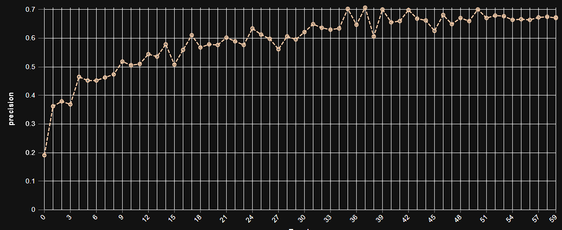 This graph illustrates the increase in model precision as training progresses over multiple epochs, showcasing the stable learning curve and high precision achieved by the YOLOv9m architecture in pothole segmentation.
Model Inference Examples
Below are conceptual examples demonstrating the model’s output when analyzing road images for pothole segmentation. The AI precisely delineates each pothole with a distinct mask, aiding in rapid assessment and maintenance planning.
Example 1: Precise Segmentation of a Pothole on Dry Asphalt
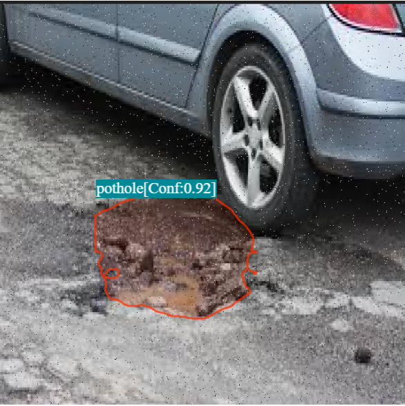 This image showcases our AI model in action, accurately segmenting the boundaries of a pothole on a dry asphalt surface, providing a clear visual representation for maintenance assessment.
Example 2: Detection of Potholes in Challenging Conditions
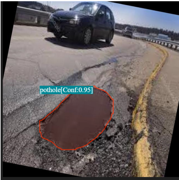 This example demonstrates the model’s capability to detect potholes even under more challenging conditions, such as those partially obscured by shadows or in areas with complex road textures.
4. Real-World Applications and Societal Impact
The deployment of this AI-powered pothole detection system is poised to create a profound impact across various urban and commercial sectors:
Automated Road Inspection Vehicles: Integration with vehicle-mounted cameras allows for continuous, high-speed scanning of road networks, generating real-time maps of defects without human intervention.
Drone-Based Surveying: Enables rapid and comprehensive assessment of hard-to-reach or large areas, such as highways, bridges, or remote roads, providing detailed visual data for maintenance planning.
Municipal Asset Management Systems: The precise, geolocated data on potholes can be fed directly into Geographic Information Systems (GIS) and asset management platforms, creating dynamic digital inventories of road conditions.
Predictive Maintenance Scheduling: By tracking the growth and emergence of potholes over time, AI can enable predictive models to forecast when and where repairs will be most urgently needed, optimizing maintenance schedules and budgets.
Public Reporting Integration: Future systems could integrate with public reporting apps, allowing citizen-submitted images to be rapidly processed by AI for verification and immediate inclusion in maintenance workflows.
Quality Control for New Road Construction: AI can be used to automatically detect early signs of defects in newly constructed roads, ensuring adherence to quality standards and addressing issues proactively.
5. Future Directions in AI-Powered Pothole Segmentation
Our commitment to innovation ensures continuous development and enhancement of our AI capabilities in road infrastructure monitoring. Future efforts will focus on:
Severity Assessment and Damage Quantification: Moving beyond simple segmentation to estimate the depth, volume, and overall severity of potholes, allowing for more precise repair cost estimation and prioritization.
Multi-Sensor Fusion: Integrating data from other sensors like LiDAR (for depth information) or thermal cameras (for moisture detection) to provide a more comprehensive understanding of road degradation.
Real-time Edge Deployment: Optimizing models for deployment directly on low-power devices, such as cameras on public transport buses or even smartphones, enabling widespread, continuous, and cost-effective monitoring.
Integration with Autonomous Repair Robotics: Developing the AI as the “eyes” for future autonomous robots designed to perform minor road repairs, creating a fully automated inspection-to-repair cycle.
Long-Term Pavement Degradation Analysis: Utilizing AI to track long-term trends in road degradation, informing strategic planning for large-scale resurfacing projects and infrastructure investment.
Conclusion
AI-powered pothole segmentation represents a significant leap forward in maintaining and optimizing our critical road infrastructure. By delivering unparalleled accuracy, real-time insights, and a data-driven approach, our solution empowers municipalities and maintenance crews to shift from reactive repairs to proactive, intelligent management. This not only translates to substantial cost savings but, more importantly, to significantly enhanced road safety and the longevity of our transportation networks, paving the way for smoother and safer journeys for everyone.